Modern Modelling Methods and hi-tech surveying techniques Mean that quarry planning is easier than ever before and no longer calls for specialist contractors
Gaining consent for new quarries is difficult and one of the challenges is helping stakeholders to understand how the quarry will develop and evolve over time. But new techniques mean that time models can help give people a better understanding and new surveying developments mean that the operation can be matched to the plan more easily than ever before.
Many people find it hard to visualise what the quarry will look like and how it will appear from their property, which makes them anxious about the development. New software means that not only can they be shown a model of the quarry at different stages, they can also see how it will look from their perspective.
The 3D visual tool from UK-based 3D Web Technologies combines data from maps, architectural drawings, and both aerial and on-site photography to create highly detailed representations of project sites and surrounding areas. With the click of a mouse, viewers can adjust the programme settings to see the impact from a perspective that they recognise, rather than having to rely on a generic fly-through.
"Members of the public will be able to look at [the images] and see it as a true, fair representation of an area they know, so if we introduce a new element, like a quarry, they'll also see it as a true, fair representation," said 3D Web Technologies director Andy Dennison.
The system has already been used by the wind power industry and the software developer is now working with community and stakeholder consultation specialist Daybreak Communication to introduce it to the minerals sector.
"I first saw the 3D technology being used on a wind farm project," said Daybreak director Paul Pounsford. "I was impressed with the software's ability to create models that enabled anyone to easily visualise the proposal. It has the potential to transform the quality of a consultation process to dispel myths and really highlight the longer-term benefits to the community and the environment of the proposed restoration."
Equipment Planning
Simulation software is also helping quarry operators to plan the layout of the quarry and their equipment needs more effectively to maximise efficiency and productivity.
"The software enables our engineers to quickly process a huge range of information covering every conceivable parameter that will affect the operation of a work site," said director of market support at Volvo Construction Equipment Region Europe, Fredrik Larsson. "It allows us to calculate a 'cost per tonne' for an operator before a machine has even been ordered." The program allows Volvo to assess, measure and input data such as tyre wear, operator costs, fuel cost, time, depreciation, interest rates, residual value, servicing times, site size, length and degree of inclines, working shift patterns, ground conditions, ground structure, rolling resistance and so on. Once all the parameters are logged, Site Simulation then calculates the optimum fleet for maximum productivity and efficiency.
"This approach allows customer to make informed decisions about what equipment is needed," said Larsson.
Checking and Referencing
Once the quarry has gained consent and the equipment fleet is operating smoothly, the quarry needs to carry out regular audits to ensure the site is operating as planned.
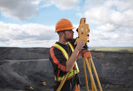
Surveys of quarries used to be carried out on an infrequent basis due to the high costs of getting an external contractor in to carry out the work and the lengthy off-site processing of data to produce meaningful results. But developments in surveying technology mean that most quarry staff could carry out surveying operations with some basic training and the cost of investing in the equipment has become more economic too.
"It is more possible to do surveying in-house than ever before - modern total stations are more functional than before and can be used in a variety of ways these days and combination with GPS adds to the capabilities," said
"These total stations also have auto functions which allow staff to set them up and leave them running unattended while the data is collected.
"This means that quarries can now carry out surveying on a more regular basis so quarries are using real data and not estimates. Quarries have previously not used positioning as much as it was expensive and not timely. Modern techniques are changing that.
"Use of surveying is expanding - there has been growing acceptance in construction and mining and that will spread to quarries too. Once they can see that it is possible to use without external help then they will start to use it too." Trimble market manager for field software Ben Atkins added, "The interpretation of the data has also improved with the latest software creating easy to use visualisation of the site. This allows quarry users to compare surface and instantly see the development. Three dimensional visualisation is also becoming more common and makes it easier to spot rogue results." Atkins believes that 3D models could be used to help with quarry planning and check that progress on site matches the plan.
Monitoring
Growing automation within mine and quarry operation means that surveying equipment could fulfil the requirement to check progress and productivity. This is something that is not fully used right now, according to Kirk.
Trimble's cooperation with
Kirk added that there is also the safety element of modern positioning technology to consider. He said that mines are already using it to check where people. "At the moment this is not particularly in real time but that will come and I can see that would also be useful in quarries too," he said.
Profile scanning is another area where modern surveying technology is helping to improve quarry operations. "This is a mature market now and the systems have become much simpler to use," explained Atkins. "Once you've set the baseline and highpoint levels, along with the profile spacing, the scanner will automatically measure the points. The software even allows it to work out what is true vertical and adjust the measurement point to take account of variations in the face." These kind of profiles can be used to improve blasting operations and tracking of progress.
There has been some talk of using vehicle mounted cameras to capture information in quarries but Kirk warns that the processing time required for this volume of data is lengthy. "In the long-term they may be useful for quarries," he said. "But today we are still experimenting with this technology.
"Managing this amount of data is the issue but it does remove the need for specific measurement - it could make it simpler and easier." Atkins points to the 3D scanner business as an example of the data volume issues. "They are used in some quarries but have been available for 10 years but have never been widely taken up because of all the data management needed." One area that Kirk believes will develop further is in the use of surveying equipment for monitoring of movement. "It is already used in mines but is coming into the quarry market too," he said. "By monitoring the surfaces better, quarries can build up a better knowledge of the deposit and will be able to detect potential failure before it happens. This means a quarry would be able to prove it is safe rather than using a one size fits all policy.
"It is clear that better data has the potential to change operations for the better," said Kirk.