The U.S. Geological Survey, Geological Survey of Alabama, and the Florida Geological Survey are coordinating the flights. Their goal is to image geology at the surface and below ground using airborne geophysical technology, with applications to hurricane resiliency and critical mineral resource evaluation. The data collected will be made freely available to the public once complete.
The airplane will fly along pre-planned fight paths relatively low to the ground at about 300 feet (100 meters) above the surface. The ground clearance will be increased to 1,000 feet (300+ meters) over populated areas in compliance with Federal Aviation Administration (FAA) regulations. The scientific instruments on the aeroplane are completely passive, with no emissions that pose a risk to humans, animals, or plant life. No photography or video data will be collected.
Instruments on the airplane will measure variations in the Earth’s magnetic field and natural low-level radiation created by different rock types. This information will help researchers develop geologic maps in three dimensions, providing scientists with the framework needed to better evaluate natural resources, groundwater, or geologic hazards.
The effort is part of the Earth Mapping Resources Initiative (Earth MRI); a nationwide collaboration between the USGS and state geologists to modernize our understanding of the nation’s fundamental geologic framework through new geologic maps, geophysical and topographic surveys, and geochemical sampling. Funding by the Bipartisan Infrastructure Law has facilitated coverage of such a large area.
Contractor Sander Geophysics Ltd. will fly this survey via a subcontract to Dewberry. Experienced pilots specially trained and approved for low-level flying will operate the aircraft. All flights will occur during daylight hours and are coordinated with the Federal Aviation Administration to comply with U.S. law.
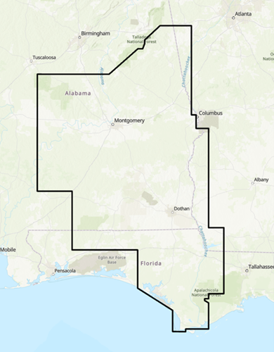
The survey will cover parts of the following counties in Alabama: Autauga, Barbour, Bibb, Bullock, Butler, Chambers, Chilton, Clay, Cleburne, Coffee, Conecuh, Coosa, Covington, Crenshaw, Dale, Dallas, Elmore, Escambia, Geneva, Hale, Henry, Houston, Lee, Lowndes, Macon, Monroe, Montgomery, Perry, Pike, Randolph, Russell, Shelby, Talladega, Tallapoosa, Tuscaloosa, and Wilcox. The survey will cover parts of the following counties in Florida: Bay, Calhoun, Franklin, Gadsden, Gulf, Holmes, Jackson, Leon, Liberty, Okaloosa, Santa Rosa, Wakulla, Walton, and Washington. The survey will cover parts of the following counties in Georgia: Carroll, Chattahoochee, Clay, Decatur, Early, Haralson, Harris, Heard, Miller, Muscogee, Quitman, Randolph, Seminole, Stewart, and Troup.