Geophysical ground exploration techniques could give a clearer view of a prospective aggregates resource and the cost of extracting it without lifting any turf. Claire Symes reports
Dwindling aggregate reserves are an issue in Europe, particularly with demand forecast to rise, but gaining permission to open a new quarry is not a quick, easy or inexpensive task. To be sure the investment, in terms of time and capital is worthwhile, quarry operators need to be sure that the resource is both suitable and will be cost effective to extract from.
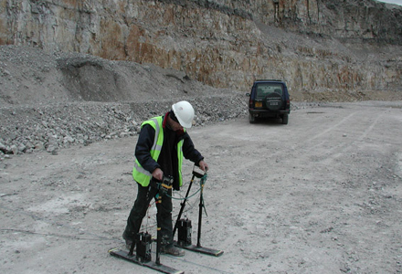
Invasive investigation of a potential new resource can be difficult in both to gain access and costly at the preliminary stages too. However, non destructive techniques such as geophysics can be useful evaluation tools and provide information on a whole site quickly and effectively.
Geophysical surveying can help a quarry operator build up an accurate evaluation of the overburden thickness and depth of weathering above competent rock. It is also possible to map the size, type and location of joints, fracture and faults in the rock body and the extent of deposits such as sand and gravel.
Nonetheless, geophysics is not widely used by the aggregates sector and Fugro Aperio chief scientist Dr Rod Eddies believes the industry is missing out.
"Developments in computer technology and investigation equipment over the last decade have significantly improved the usefulness of geophysical investigations to the construction industry," said Eddies. "Faster acquisition rates, greater sensitivity and the raw processing power of modern equipment means that visualisation of the data is possible in the field and after processing can give more accurate results.
"Addition of real-time GPS positioning coupled to geophysical survey equipment has also boosted both acquisition rates and relocation accuracy. It is also possible to combine and overlay other site data with the survey results through use of geographical information systems (GIS), which can be very effective for planning purposes." According to Eddies, there are a number of different geophysical survey techniques - surface and borehole based - open to the quarrying industry and each has different benefits and limitations.
Survey techniques
"Seismic refraction will help determine the depth to competent bedrock and map the overburden thickness," explained Eddies. The technique works by measuring travel-times of compressional waves travelling through the subsurface. These travel-times can be related to the velocity contrasts between layers in the subsurface.
"This technique also gives a good indication of whether it is possible to rip away the overburden - there is an established relationship between compressional seismic velocity and the rippability of the material.
"The interface between the unconsolidated material and bed rock can also be mapped and, if the rock is above the water table, the location of faults, fractures, caves and solution features can also be found using ground penetrating radar (GPR) methods." GPR can be used to create either a two or three dimensional image of the rock mass to a depth of about 20m from the ground surface. GPR response arises from changes in electrical properties of the shallow subsurface - often associated with structure - by means of transmitting and subsequently receiving reflected pulses of high frequency electromagnetic radiation. GPR gives good results in dry conditions but is much less effective in ground that is wet or is clay rich.
"It is important to have an understanding of the local geology to ensure the right geophysical technique is selected to give the optimum results," said Eddies.
Seismic reflection gives similar results to GPR but also measures acoustic reflectivity by bouncing sound waves off the boundaries between different rock types or structural features. It can be analysed to indicate changes in stratigraphy and the structural characteristics of the rock.
"In an alluvial deposit it is possible to measure the distribution of the gravel layers because of their high resistivity," said Eddies. Any significant clay layers in the deposit will show up with lower resistivity and mapping the changes would show the shape of the gravel body and areas of high clay content, which might make it an uneconomic for extraction due to amount of washing required.
"Electromagnetic conductivity surveys are useful to depths of about 20m and are very good from a reconnaissance perspective," said Eddies. "Information can be used to zone the deposit and delineate the edge of a sand body or clay lenses based on electrical properties. This type of survey is very quick to undertake too." One of the newest surface-based geophysical tools is multichannel analysis surface waves (MASW) which can be used to map ground stiffness down to a depth of 20 to 25m, depending on the ground conditions. "The method derives the shear wave velocity of the material from acoustic waves generated at the ground/air interface," explained Eddies. "The lower the shear wave velocity, the lower the stiffness.
Another useful tool is microgravity. This geophysical technique involves measurement of variations in the earth's gravitational field. In general, the magnitude of the field is dependent on several factors, including latitude, elevation and earth tides. However, by applying corrections to remove the effects of these factors, variations can be attributed to lateral changes in subsurface density only.
This is a slower technique to undertake in the field but maps the changes in density of the rock mass can be very useful.
Using boreholes provides access to more geophysical surveying techniques. "The commonest is seismic tomography, which measures seismic waves transmitted from one borehole to another and can provide information on how the material properties vary with depth," said Eddies. "This method can be carried out using a pair of boreholes or a network of them can be used for a cross hole seismic analysis. A key benefit of seismic borehole measurements is that the seismic velocity of a rock body can be measured as a function of depth and interpreted for characteristics such as rock quality and fracture density."
Quarry benefits
The main benefit of these techniques to quarry operators is the ability to use the geological and structural data to plan the quarry layout and check for any slope stability or groundwater problems without any excavation on site. Through this information it is possible to estimate the production cost at a very early stage.
"Innovation of geophysical techniques is continual and current developments are likely to offer further improvements in three dimensional visualisation in next few years," said Eddies. "This will allow clients to more easily understand the information that is gathered in this type of survey.
"The bulk of the work undertaken by the onshore geophysical industry is geared towards establishing pre-construction geotechnical and geological properties and environmental studies. But there is a huge opportunity for the quarrying industry to take advantage of the benefits of established geophysical techniques. Wider use could give a great deal of understanding before excavation starts and provide more detailed information for planning."