A new
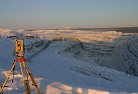
Measuring and monitoring is a key part of quarry operations and a new system from Topcon promises to improve accuracy and speed up this essential function. The company has joined forces with German monitoring software provider De Bertges and Switzerland-based inclination sensor manufacturer Wyler to create an image based monitoring system.
"We have taken Topcon's imaging total station technology, added Wyler's precision inclination sensors and combined it with Dr Bertges DC3 monitoring software," said Topcon product marketing manager Ian Stilgoe. "By combining data from the Wyler sensors and Topcon Total Station or GNSS in the DC3 software range, we developed a solution which is truly pioneering: imaged monitoring." According to Topcon the system can be used in all types of monitoring projects from construction through to rock face stability.
The DC3 system is at the centre of the solution and offers a fully automated surveying system for terrain or structure movements. It offers measuring, analysis, and if needed alarming, using Topcon's precise positioning technology and Wyler's sensors. It detects and models subsidence, tilt and valley convergence or divergence processes and can transmit data by radio-telemetry and
The communications and data acquisition system allows the link of DC3 software to different kinds of sensors and communication channels. Different kinds of sensors can be combined with each other: for instance a Total Station and GNSS sensors, inclination measurers, meteo and geosensors and even a webcam. DC3 consists of at least one central data processing unit and several external sensor control units. The acquisition of the sensor data by GNSS and Total-Stations may take place in a real-time, near-online and in offline mode. The data-exchange with the DC3 Software can also run online as well as offline.